The expansive clay terrain north of Dallas presents a distinct challenge for seismic site classification—one that standard penetration testing alone cannot resolve. McKinney sits atop the Eagle Ford Group and Quaternary alluvium, where near-surface shear wave velocities can vary dramatically across short distances due to the interbedded shale, limestone, and residual clay profiles. For projects requiring IBC Chapter 16 compliance, our team deploys active-source MASW surveys with 24-channel seismographs and 4.5 Hz geophones to capture VS30 values directly from surface wave dispersion, eliminating the uncertainty of proxy-based correlations. This method proves particularly valuable on sites where the expansive clay behavior demands both seismic classification and shrink-swell characterization before foundation design proceeds.
A thirty-meter shear wave velocity profile is not a single number—it is a stratigraphic fingerprint that governs how a building will respond to ground motion in McKinney’s variable Cretaceous formations.
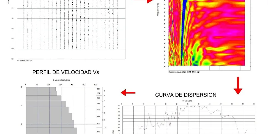
Methodology and scope
Local considerations
A 24-channel Geometrics Geode seismograph with a 4.5 Hz geophone string deploys across the site in under forty minutes, but the real risk lies in what happens before the first hammer strike. McKinney’s summer soil conditions—dry, cracked clay over desiccated shale—create poor geophone coupling that attenuates high-frequency surface wave energy, biasing the dispersion curve toward lower phase velocities. We mitigate this by excavating shallow pilot holes and seating each geophone in moistened, compacted native soil, verifying coupling with tap tests on every channel. Urban noise from nearby construction, traffic on SH-121, and overhead utility lines introduces coherent noise that can mask the fundamental Rayleigh wave mode; our field processing includes real-time FK filtering and stacking of multiple shot records to suppress these artifacts before the dispersion image is generated.
Applicable standards
ASCE 7-22 Chapter 20: Site Classification Procedure for Seismic Design, IBC 2021 Section 1613: Earthquake Loads – Site Class Determination, ASTM D4428/D4428M-14: Standard Test Methods for Crosshole Seismic Testing (surface-wave adaptation)
Associated technical services
VS30 Site Classification Survey
Active MASW acquisition with 24-channel array processed to deliver a 30-meter depth-averaged shear wave velocity and the corresponding IBC Site Class (A through F). Each report includes the dispersion curve, inverted Vs profile, and a signed engineering interpretation suitable for permit submission in Collin County. Typical turnaround is five business days from field acquisition to final PDF.
Deep Shear Wave Velocity Profiling
Extended-spread MASW or combined active-passive (refraction microtremor) acquisition for projects requiring Vs profiles to 60 meters or more—common where the Eagle Ford shale transitions to the deeper Buda Limestone. This data supports site-specific ground response analysis when the standard VS30-based site coefficients are insufficient for performance-based design under ASCE 7 Chapter 21.
Typical parameters
Frequently asked questions
When does IBC require a VS30 measurement instead of using the default Site Class D assumption in McKinney?
IBC Section 1613.3.2 permits classifying a site as Class D by default only when the soil properties are not known in sufficient detail. For structures assigned to Seismic Design Category C or higher—common in McKinney given the proximity to the Meers Fault system—the structural engineer often requests a measured VS30 to avoid the conservatism built into the default assumption. A measured Site Class C profile (VS30 between 360 and 760 m/s) can reduce the design spectral response acceleration by up to 30% compared to the Class D default, directly affecting the lateral force-resisting system cost.
How deep do you need to drill a borehole to correlate with the MASW data?
We do not require a dedicated borehole for the MASW survey itself; the method is fully non-invasive. However, when a geotechnical boring already exists on site, the stratigraphic log provides valuable constraint for the inversion process. A boring to 10–15 meters depth is typically sufficient to identify the depth to weathered rock or the top of the Eagle Ford shale, which we then use to reduce the non-uniqueness of the inverted Vs profile. Without a boring, the inversion relies solely on the dispersion curve misfit, which is still valid but carries slightly higher uncertainty in the layer boundary depths.
What is the typical cost range for a MASW / VS30 survey on a single-family residential lot in McKinney?
For a standard single-family lot survey with one or two MASW lines and a VS30 report suitable for permit submission, the cost ranges from US$1,470 to US$3,140 depending on site accessibility, line length, and whether deeper profiling beyond 30 meters is required. Sites with heavy tree cover, steep grades, or limited access for the geophone spread tend toward the upper end of that range due to additional field time.
Can you run MASW on a site with existing fill or pavement?
Yes, but with important caveats. Asphalt or concrete pavement creates a high-velocity cap that traps surface wave energy and can generate higher-mode interference in the dispersion image. We typically core through pavement at each geophone station and couple directly to the subgrade, or we shift the array to an unpaved portion of the site if available. For sites with deep, uncompacted fill, the low-velocity layer can produce an inverse dispersion curve that requires careful mode identification during processing—our analysis software includes multi-mode inversion capability to handle these cases.