The hollow-stem auger rig is the first thing you hear on a tunnel pre-excavation site in McKinney—its constant torque churning through the stiff upper crust of the Houston Black clay before it hits the wet, silty loam below. By the time we reach planned tunnel invert depth, usually 15 to 25 feet, the split-spoon sampler has already told us the story: soft to very soft cohesive soils with SPT N-values dropping below 4. That transition zone, where the fissured clay gives way to water-bearing alluvium, is where most tunneling problems start in this part of Collin County. Our geotechnical analysis for soft soil tunnels combines multi-point SPT drilling, undisturbed Shelby tube sampling, and laboratory strength testing under effective stress conditions to build a ground model that the contractor can actually work with. When alignment passes through the Taylor Marl outcrops east of US-75, we often couple the investigation with CPT testing to capture a continuous profile of tip resistance and pore pressure, because the marl’s variability in carbonate content can change face stability demands within a few hundred feet of drive.
In McKinney’s floodplain soils, an SPT N-value below 4 combined with a liquidity index above 1.2 means face stability demands continuous support and real-time pore pressure monitoring during excavation.
Methodology and scope
Local considerations
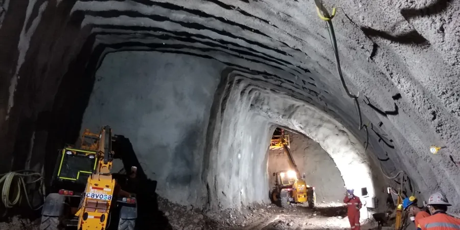
IBC Chapter 18 and OSHA Subpart S set the baseline for tunnel safety, but in McKinney the real risk driver is the transition from stiff expansive clay to soft alluvium within a single tunnel drive. We have seen projects where the contractor advanced confidently through the clay, only to hit a buried paleochannel filled with saturated silt that had never appeared on the original geotechnical baseline report. Face loss in those conditions can propagate to the surface within hours, especially where the overburden is less than 1.5 times the tunnel diameter. Our analysis explicitly maps these transitions using a dense grid of borings spaced no more than 100 feet apart along the alignment, supplemented with MASW surveys to image shear wave velocity contrasts that often correlate with channel boundaries. The second major risk is time-dependent settlement behind the tail void: in the soft alluvium, consolidation settlement can account for 60 percent of total surface settlement over a two-year period, a figure we quantify with oedometer tests and coupled consolidation analysis so that the contractor can adjust grouting pressure and backfill timing before the first ring is installed.
Applicable standards
ASTM D1586-18 Standard Test Method for Standard Penetration Test (SPT), ASTM D2487-17 Standard Practice for Classification of Soils for Engineering Purposes (Unified Soil Classification System), IBC Chapter 18 Soils and Foundations / Section 1810 Deep Foundations and Tunnels, ASCE 7-22 Minimum Design Loads for Buildings and Other Structures (Seismic Site Class D/E), OSHA 29 CFR 1926 Subpart S – Underground Construction, ASTM D4767-11 Standard Test Method for Consolidated Undrained Triaxial Compression Test for Cohesive Soils
Associated technical services
Tunnel Alignment Geotechnical Baseline Report (GBR)
We compile SPT data, CPTu soundings, triaxial strength envelopes, and Atterberg limits into a defensible GBR that defines baseline ground behavior for the contractor. This document delineates soil units along the drive, assigns anticipated face conditions, and quantifies swelling pressures and consolidation settlements—giving the owner and contractor a shared reference for differing site conditions claims under FIDIC or EJCDC contract frameworks.
Face Stability and Pre-Support Design Analysis
Using undrained shear strength profiles and effective stress parameters from laboratory testing, we calculate required face support pressure and evaluate pre-support options including spiling, pipe arch canopies, and permeation grouting. For McKinney’s floodplain reaches, we model pore pressure dissipation rates and recommend real-time monitoring trigger levels that tie directly to TBM advance rate and face pressure adjustments.
Typical parameters
Frequently asked questions
How much does a geotechnical analysis for a soft soil tunnel cost in McKinney?
Budget between US$4,630 and US$15,120. The final cost depends on tunnel length, number of borings required, and the laboratory testing program—projects crossing both the western clay uplands and eastern floodplain typically land in the upper half of that range because of additional triaxial and consolidation tests.
What makes McKinney’s soils particularly challenging for tunneling?
The city sits on two very different soil provinces: the stiff, expansive Houston Black clay on the uplands west of US-75, and the soft alluvial silts and fine sands of the Trinity River floodplain to the east. Tunnel alignments often cross both, so the ground behavior can change from stable face conditions to running ground within a few hundred feet.
Which laboratory tests are critical for soft soil tunnel design?
We rely on consolidated-undrained triaxial compression with pore pressure measurement to get undrained shear strength and effective stress parameters; one-dimensional consolidation tests to estimate time-dependent settlement behind the tail void; and Atterberg limits plus free-swell tests to evaluate expansion potential in the clay sections.
How do you determine the right support pressure for a tunnel face in soft ground?
We calculate required face support pressure using limit equilibrium methods that account for undrained shear strength, overburden stress, and groundwater pressure. In McKinney’s floodplain silts, the liquidity index often drives the analysis—when LI exceeds 1.0, we specify continuous face support and tie advance rate to real-time pore pressure monitoring.
What geophysical methods complement the drilling program?
MASW surveys are particularly useful along McKinney tunnel alignments to map shear wave velocity contrasts across paleochannel boundaries that conventional borings can miss. We run lines parallel to the alignment and interpret Vs profiles to refine the ground model between borehole locations.