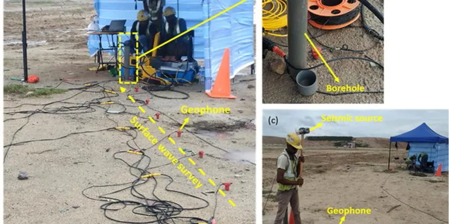
The geophone array stretches across the site, each sensor spiked firmly into the clay. A triggered weight drop sends shear waves through the subsurface layers. The recording unit captures every refraction and dispersion curve. That data becomes the backbone of a seismic microzonation map for your project in McKinney. We don't guess at site class. We measure VS30 directly with MASW and refraction methods, then overlay the results on a detailed grid. The output tells you where the ground will shake harder and where it stays relatively quiet. For a city expanding as fast as McKinney Texas, where new subdivisions and commercial pads break ground monthly, this level of resolution changes how engineers position structures and size foundations. It also feeds directly into the liquefaction assessment when the water table sits high in the Eastern Cross Timbers transition soils.
A single site class assumption across a variable site is a tax on your foundation budget. A microzonation map replaces assumption with measurement.
Methodology and scope
Local considerations
McKinney sits at roughly 630 feet elevation on the northern edge of the Dallas-Fort Worth metroplex, far from the New Madrid and West Texas seismic zones but not seismically silent. The USGS National Seismic Hazard Model assigns a 2% probability of exceedance in 50 years PGA around 0.05–0.08g for the area. That number looks low until you factor in the soft alluvial soils along the East Fork of the Trinity River basin. Those deposits can amplify ground motion by a factor of two or more compared to the limestone bedrock. A uniform hazard spectrum won't capture that amplification. A microzonation study will. When the city reviews a plat or a commercial permit, the geotechnical report carries more weight if it includes site-specific seismic hazard analysis rather than a copy-paste USGS value. We help developers in McKinney Texas meet that standard without over-designing the structural system.
Applicable standards
ASCE 7-22 Minimum Design Loads and Associated Criteria for Buildings and Other Structures, IBC 2021 Section 1613 Earthquake Loads (adopted by City of McKinney), ASTM D4428/D4428M-14 Standard Test Methods for Crosshole Seismic Testing (MASW adaptation)
Associated technical services
Geophysical Survey & VS30 Profiling
MASW and seismic refraction lines on a grid tailored to your site. We deliver VS30 values and 1D shear wave velocity profiles for every measurement point, classified per ASCE 7 site class definitions.
Subsurface Calibration Borings
SPT borings or CPT soundings at key grid nodes to tie the geophysical data to soil type, density, and groundwater depth. This calibration is essential for liquefaction triggering analysis.
Hazard Map & Engineering Report
Contour maps of site class, PGA amplification factor, and liquefaction potential index. The report includes design spectral accelerations for any coordinate on the site, ready for the structural engineer.
Typical parameters
Frequently asked questions
What does a seismic microzonation study for a site in McKinney Texas typically cost?
The investment depends on site acreage and grid density. For most commercial and subdivision-scale projects in McKinney, the study ranges from US$3,770 for a focused survey with two or three transects up to US$15,820 for a full-coverage grid with calibration borings and a comprehensive hazard map. We provide a fixed-price proposal after reviewing your site plan and geotechnical objectives.
Is seismic microzonation required by the City of McKinney for building permits?
The City of McKinney adopts the IBC with local amendments. Chapter 16 requires seismic design based on site class. If you default to Site Class D without measurement and the subsurface actually classifies as C or B, you may be over-designing. If the soil is softer and classifies as E, you may be under-designing. A microzonation study gives the building official documented justification for the design spectral values used in the structural calculations.
How long does a microzonation survey take and will it delay our grading schedule?
Fieldwork on a typical 10- to 20-acre parcel in McKinney takes two to three days. We coordinate directly with your earthwork contractor so the geophone lines and weight-drop operations stay out of the critical path. The draft site class map is available within five business days after field completion, fast enough to feed into foundation design before the grading is finished.