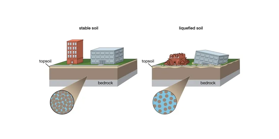
A hollow-stem auger rig advances through the stiff clay crust, then the automatic trip hammer begins its 30-inch drop sequence. Split-spoon samples come up from 15, then 25 feet—loose silty sand with traces of gravel, typical of the Trinity River tributary deposits underlying much of McKinney. The drill crew logs blow counts while our geotechnical engineer watches for the telltale low-N zones that trigger a liquefaction screening under ASCE 7-22 and IBC 2021. McKinney sits on Pleistocene terraces and Holocene alluvium where saturated granular lenses at depths of 10 to 35 feet can lose shear strength during a design-level seismic event. A standard SPT drilling program provides the raw data, but the analysis requires correcting for overburden pressure, hammer energy ratio, and fines content before applying the NCEER/Youd-Idriss procedure—every variable shifts the factor of safety meaningfully.
A fines content correction of just 5% can shift the liquefaction factor of safety by 0.15 to 0.25 in McKinney's silty alluvial sands—skip the lab and you are guessing.
Methodology and scope
Local considerations
In McKinney, we frequently see site plans with detention ponds excavated right next to building pads—and nobody on the design team has considered what happens when a saturated sand lens sits five feet below the pond bottom. The cyclic shear stress ratio jumps because the overburden stress is lower, and the groundwater source is now permanent. This is not a hypothetical scenario; we evaluated a retail site along US-75 where the detention basin created a liquefiable condition that did not exist in the pre-grading exploration. The simplified procedure showed a factor of safety of 0.8 under the design earthquake, and differential settlement estimates exceeded 4 inches across the foundation footprint. The fix involved deepening the basin with a cutoff wall and installing stone columns beneath the affected pad area. Another repeat offender is the assumption that clayey soils are non-liquefiable without checking the plasticity index—we have sampled silty sands in McKinney that classify as CL-ML under USCS but behave as contractive granular soils under cyclic loading. The Bray-Sancio criteria for fine-grained soils help distinguish truly non-liquefiable clays from silts that will trigger a problematic assessment if ignored.
Applicable standards
ASCE 7-22 Chapter 11: Seismic Design Criteria, IBC 2021 Section 1803.5.12: Liquefaction assessment, ASTM D1586-18: Standard Test Method for Standard Penetration Test (SPT), ASTM D2487-17: Unified Soil Classification System, NCEER/Youd-Idriss 2001: Liquefaction resistance of soils
Associated technical services
SPT-Based Liquefaction Screening
Drilling with automatic trip hammer per ASTM D1586-18, energy-corrected blow counts, and application of the NCEER/Youd-Idriss simplified procedure to calculate factor of safety against liquefaction triggering for each granular layer encountered.
Post-Liquefaction Settlement Analysis
Volumetric strain estimation using the Tokimatsu-Seed and Ishihara-Yoshimine methods, providing the structural engineer with differential settlement magnitudes for mat foundation design or ground improvement justification.
Lateral Spreading Displacement Assessment
Empirical displacement calculations using the Youd et al. (2002) multilinear regression model, critical for sites adjacent to McKinney's creek channels where free-face geometry amplifies permanent ground displacement.
Ground Improvement Design for Liquefaction Mitigation
Stone column layout, vibrocompaction specifications, and post-treatment verification testing programs designed to achieve a target factor of safety of 1.3 or greater under the design earthquake.
Typical parameters
Frequently asked questions
What triggers a liquefaction study requirement in McKinney, and which building code section applies?
IBC 2021 Section 1803.5.12 and ASCE 7-22 Chapter 11 require a liquefaction assessment when a structure is assigned to Seismic Design Category C or higher and the subsurface investigation reveals saturated, loose to medium-dense granular soils within 50 feet of grade. McKinney falls in SDC B to C depending on site class, but for Risk Category III and IV structures (schools, emergency facilities, large assembly buildings), the requirement kicks in if the geotechnical exploration identifies sands with corrected SPT blow counts below 15 in the upper 30 feet and groundwater within 30 feet. We prepare the analysis using the NCEER modified procedure with site-specific peak ground acceleration from the USGS hazard maps, typically PGA values between 0.08g and 0.12g for the 2% in 50-year event.
How much does a soil liquefaction analysis cost for a commercial site in McKinney?
For a typical commercial lot or pad site in McKinney, a complete liquefaction evaluation—including two to three SPT borings to 40-foot depth, laboratory fines content and Atterberg limits on selected samples, cyclic resistance ratio calculation, and a stamped report—runs between US$2,480 and US$4,460. The spread depends on the number of borings required, whether CPT soundings are added for stratigraphic refinement, and if post-liquefaction settlement or lateral spreading displacement analyses are needed for the structural engineer's foundation design.
What soil parameters most affect the liquefaction factor of safety in the McKinney area?
Three parameters dominate the analysis in our local geology: corrected SPT blow count (N1)60, fines content percentage, and groundwater table elevation. In McKinney's alluvial deposits, fines content typically ranges from 5% to 35%, and even a 10% increase in fines can raise the cyclic resistance ratio by 20-30% under the NCEER framework. Groundwater fluctuates seasonally—we have measured differences of 3 to 5 feet between summer and winter levels in monitoring wells along Wilson Creek—so we always recommend using the highest observed seasonal groundwater to avoid an unconservative analysis.